Industrial Avalanche Mitigation Methods for Worksites, Exploration, Survey, Resource Roads, Energy Corridors, and Utilities

July 18, 2024 By Alpine Solutions

Industrial Avalanche Mitigation Methods: Understanding the Risks

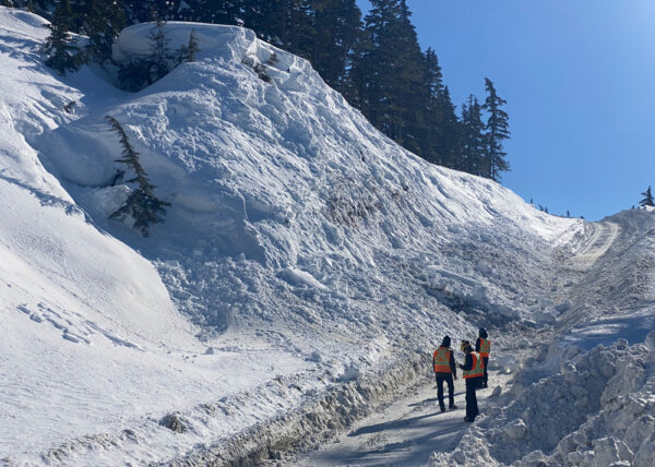
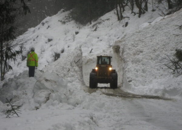
Outdoor worksites, resource roads, exploration or survey activities, mining access roads, and operations may be exposed to avalanche hazards. We will be explaining the industrial avalanche mitigation methods for these operations facing an avalanche hazard. Though the primary element at risk is people, other valuable assets, such as equipment or temporary facilities (e.g., a diamond-drilling rig), can also be at risk.

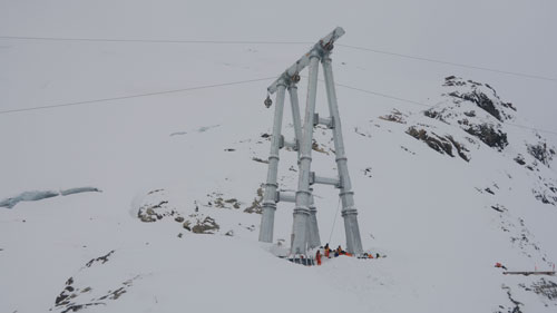
Logging access roads, harvesting operations, standing timber resources, and reforestation may also face avalanche hazards (Weir, 2002). Cross-mountain transmission and local distribution lines are vulnerable to avalanches (Stethem et al., 2003). The avalanche threat to pipelines and transmission lines reflects the risk of environmental damage (pipelines) or loss of service in utilities (transmission and pipelines). While snow avalanches do not usually affect pipelines buried below the ground surface, they can threaten above-ground infrastructure (e.g., valves) and access routes. Due to these hazard, industrial avalanche mitigation methods will need to be explored and applied to the various operational needs.

Why Industrial Avalanche Mitigation Methods are Crucial

  • Safety of Personnel: Protecting workers in outdoor environments like construction sites, logging areas, and maintenance routes is critical. Avalanches pose significant risks, and proper safety measures can prevent accidents and save lives.
  • Protection of Equipment and Facilities: Avalanches can cause severe damage to equipment and temporary facilities, leading to substantial financial losses. Understanding and implementing industrial avalanche mitigation methods helps protect valuable assets and reduce repair or replacement costs.
  • Environmental Protection: For projects involving pipelines and transmission lines, avalanches pose a risk of environmental damage. A ruptured pipeline can lead to hazardous material spills, causing significant environmental harm and legal repercussions.
  • Service Continuity: Avalanches can disrupt essential services, such as electricity and communication networks. Ensuring these services remain uninterrupted is crucial for maintaining public trust and operational efficiency.
  • Resource Roads Accessibility: Avalanches can bury resource roads, creating significant inaccessibility issues. This can hinder access to worksites, delay projects, and increase operational costs. Managers must consider industrial avalanche mitigation methods to ensure reliable access routes.

Typical Elements at Risk and Avalanche Mitigation Measures

Industrial avalanche mitigation methods summarizes both planning and operational risk management guidelines for specific activities or industry sectors.

Different elements at risk generally fit within the following groups:

  • Persons: Occupants, pedestrians, workers, motorists, passengers, etc.
  • Structures: Unoccupied, occupied, essential and/or emergency service, etc.
  • Infrastructure: Chairlifts, utilities, transmission, transportation, resource roads, communication, etc.
  • Vehicles, Aircraft, or Rail Stock: On roads, railways, landings, helipads, over snow, etc.
  • Natural Resources and Environment: Forest cover, fish-bearing streams, etc.
  • Goods (Usually in Transit): Manufactured goods, commodities, and resources.

Each element at risk has different vulnerabilities and economic values, making some more susceptible to avalanches than others, and some with lower risk tolerance. It is also important to consider whether an element at risk is static or mobile to determine exposure.

Non-Avalanche Workers at a Fixed Outdoor Worksite

Example: Non-avalanche workers at a fixed outdoor worksite (Forest workers in and around a yarder)

Avalanche

During A Risk Analysis Avalanche Hazard is Identified:

  • Avalanche Size: An avalanche greater than a size 1 can  impact the stationary worksite.
  • Frequency of Avalanches: Avalanches greater than a size 1 are likely to occur within a 30 year period.

During the Planning Phase Avalanche Professionals Will be Assessing the Following:

  • Terrain Assessment: On site assessment of the avalanche slope that can produce the hazard. How likely is it for the hazard to change minutes to hours for the specific work area.
  • Avalanche Hazard: Frequency-magnitude analysis tells us how often the avalanche of greater than size 1 will occur at the work site. Analysis of vegetation and climate studies, historical and human records will be needed.
  • Assessment Techniques and Decision Aids: Qualitative procedures; terrain exposure classification.
  • Supporting Map Types: Avalanche path map.
  • Mitigation Options: Location planning. Specification of short-term operational measures (e.g. developing operational risk assessment aids and evacuation plans).

Operations that are needed to support avalanche mitigation:

  • Daily Assessment: Daily assessment of the slope and surrounding areas that can produce the avalanche hazard during periods of increased hazard.
  • Avalanche Hazard Forecasting: Daily weather observations and conditions reports. Daily to monthly snowpack and avalanche observations.
  • Supporting Map Types: Terrain exposure ratings or map; locator map or avalanche atlas
  • Mitigation Options: Worksite access restrictions and precautionary evacuation; avalanche forecasting; procedure and policy outlined in an Avalanche Safety Plan

Non-Avalanche Workers Engaged in Backcountry Travel

Example: Exploration and survey crews.

Survey Worker Industrial Avalanche Mitigation

During A Risk Analysis Avalanche Hazard is Identified:

  • Avalanche Size: An avalanche greater than a size 1 can  impact the stationary worksite.
  • Frequency of Avalanches: Avalanches greater than a size 1 are likely to occur within a 30 year period.

During the Planning Phase Avalanche Professionals Will be Assessing the Following:

  • Terrain Assessment: On site assessment of the avalanche slopes in the operational area that can produce the hazard. Evaluating changing hazards within minutes to hours.
  • Avalanche Hazard: Frequency-magnitude analysis tells us how often the avalanche of greater than size 1 will occur at the work site. Analysis of vegetation and climate studies, historical and human records will be needed.
  • Assessment Techniques and Decision Aids: Qualitative procedures; terrain exposure classification.
  • Supporting Map Types: Terrain exposure map; locator map.
  • Mitigation Options: Mitigation is primarily accomplished through short-term operational measures (e.g. avalanche forecasting and a risk matrix).

Operations that are needed to support avalanche mitigation:

  • Daily Assessment: Daily regional-scale assessments, with ongoing slope-scale reassessments during periods of increased hazard.
  • Avalanche Hazard Forecasting: Daily weather observations and conditions reports. Daily to monthly snowpack and avalanche observations.
  • Supporting Map Types: Terrain exposure ratings or map; locator map or avalanche atlas
  • Mitigation Options: Backcountry access restrictions; avalanche forecasting; procedure and policy.

Resource Roads

Example: Any Camp or Worksite Access

Avalanche on Resource Road

During A Risk Analysis Avalanche Hazard is Identified:

  • Avalanche Size: An avalanche greater than a size 2 can  impact the resource road.
  • Frequency of Avalanches: Avalanches greater than a size 2 are likely to occur within a 30 year period.

During the Planning Phase Avalanche Professionals Will be Assessing the Following:

  • Terrain Assessment: On site assessment of the mountain region as well as the avalanche paths directly affecting the road for an exposure time scale of minutes to hours. Assessment of a group of paths (i.e. avalanche area) is often useful.
  • Avalanche Hazard: Frequency-magnitude analysis tells us how often the avalanche of greater than size 2 will occur at the work site. Analysis of vegetation and climate studies, historical and human records will be needed.
  • Assessment Techniques and Decision Aids: Qualitative or quantitative procedures depending on objectives, exposure, and costs; linear hazard assessment.
  • Supporting Map Types: Locator map; linear hazard map.
  • Mitigation Options: Location planning, avalanche protection structures, seasonal closures, signage.

Operations that are needed to support avalanche mitigation:

  • Daily Assessment: Daily regional-scale assessments, with ongoing mountain-scale reassessments during periods of increased hazard.
  • Avalanche Hazard Forecasting: Daily weather observations and conditions reports. Daily to monthly snowpack and avalanche observations.
  • Supporting Map Types: Terrain exposure ratings or map; locator map or avalanche atlas
  • Mitigation Options: Road access restrictions; avalanche forecasting; procedure and policy; occasional artificial triggering using explosives or remote avalanche control systems in place.

Occupied Structures

Example: Storage facilities, powerhouse, field offices, etc.

Avalanche Run Out

During A Risk Analysis Avalanche Hazard is Identified:

  • Avalanche Size: An avalanche greater than a size 1 can  impact the structure. We also consider impact force of the powder cloud that can be generated by a large avalanche. An impact force of 1KPa which is force strong enough to break windows.
  • Frequency of Avalanches: Avalanches greater than a size 1 or impacts with 1KPa are likely to occur within a 300 year period.

During the Planning Phase Avalanche Professionals Will be Assessing the Following:

  • Terrain Assessment: Path-scale assessment for an exposure time scale of years to decades.
  • Avalanche Hazard: Frequency-magnitude analysis tells us how often the avalanche of greater than size 2 will occur at the work site. Analysis of vegetation and climate studies, historical and human records will be needed.
  • Assessment Techniques and Decision Aids: Qualitative or quantitative procedures based on objectives; impact-based classification (may require numerical runout modeling).
  • Supporting Map Types: Hazard zone map.
  • Mitigation Options: Location planning; reinforcement and design of structures; and, track and runout zone measures. Specification of short-term operational measures (e.g. developing operational risk assessment aids and evacuation plans).

Operations that are needed to support avalanche mitigation:

  • Assessment: Daily drainage- to regionalscale assessments, with ongoing path-scale reassessments during periods of increased hazard
  • Avalanche Hazard Forecasting: Hourly to daily weather observations and conditions reports. Daily to weekly snowpack and avalanche observations.
  • Supporting Map Types: Avalanche atlas
  • Mitigation Options: Warning systems; precautionary evacuation; restricted access; artificial triggering.

Telecommunications, Transmission line, Surface pipeline and above-ground infrastructure

Avalanche Mitigation Infrastructure

During A Risk Analysis Avalanche Hazard is Identified:

  • Avalanche Size: An avalanche greater than a size 2 can  impact the structure.
  • Frequency of Avalanches: Avalanches greater than a size 2 are likely to occur within a 30 – 100 year period.

During the Planning Phase Avalanche Professionals Will be Assessing the Following:

  • Terrain Assessment: Mountain-scale followed by pathscale assessment for an exposure time scale of minutes to hours. Assessment of a group of paths (i.e. avalanche area) is often useful.
  • Avalanche Hazard: Frequency-magnitude analysis tells us how often the avalanche of greater than size 2 will occur at the work site. Detailed slope and terrain specific analysis of vegetation and climate studies, historical and human records will be needed. Tools like LiDAR can be useful for analysis in remote areas that lack sufficient mapping.
  • Assessment Techniques and Decision Aids: Locally validated numerical runout modeling; impact-based classification.
  • Supporting Map Types: Avalanche path map; Hazard zone map.
  • Mitigation Options: Location planning; reinforcement and design of structures; track and runout zone measures (e.g. splitting wedges).

Operations that are needed to support avalanche mitigation:

  • Assessment: Daily regional-scale assessments, with ongoing mountain- to drainagescale reassessments during periods of increased hazard.
  • Avalanche Hazard Forecasting: Daily to weekly weather observations and conditions reports. Weekly to monthly snowpack and avalanche observations.
  • Supporting Map Types: Avalanche atlas
  • Mitigation Options: Sufficient mitigation is typically achieved at the planning stage. Otherwise short-term measures (e.g. avalanche forecasting and artificial triggering) are considered.

Avalanche Mitigation Expertise

Our team of industry leading Avalanche Professionals are licensed and provide specific avalanche hazard mitigation to each projects unique specifications.

Source

Technical Aspect of Snow Avalanche Risk Management

Reader Interactions

Leave a Reply

Your email address will not be published. Required fields are marked *