A developing La Nina for Canada Winter 2024

July 16, 2024 By Alpine Solutions

La Nina and El Nino

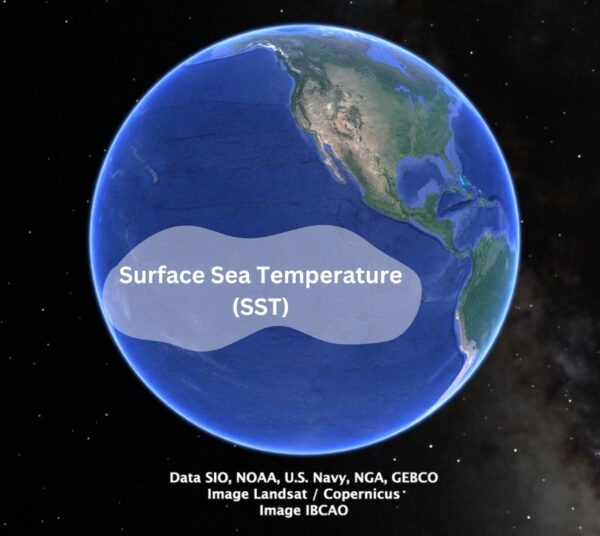
La Nina and El Nino are two opposing climate patterns based on temperature anomalies in the sea surface temperature (SST) of the Pacific Ocean.
Sea Surface Temperature

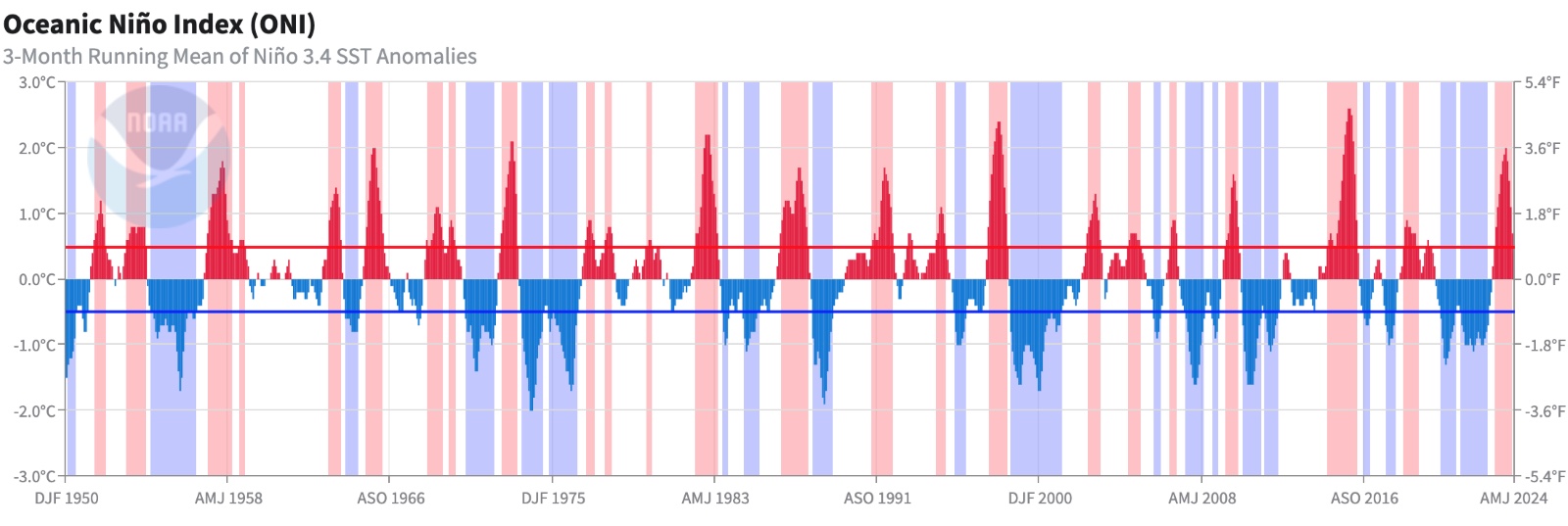
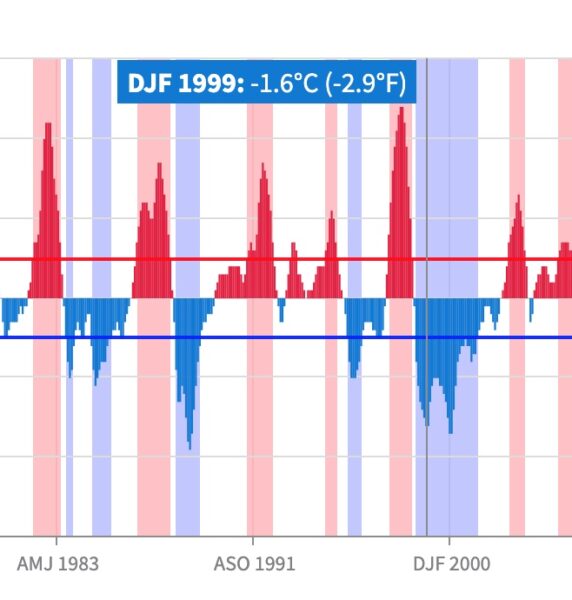
An anomaly is categorized as La Nina or El Nino when a 5-consecutive 3-month running mean of sea surface temperatures is above (+0.5°C) or below (-0.5°C) the threshold, respectively. This standard of measurement is known as the Oceanic Niño Index (ONI). These anomalies have a strong impact on climate.

Oceanic Nino Index (ONI)

The Oceanic Nino Index (ONI) defines warm (red) and cold (blue) phases based on sea surface temperature (SST) anomalies in the Niño 3.4 region.

Ocean Nino Index

Source:https://www.cpc.ncep.noaa.gov/data/indices/oni.ascii.txt https://www.ncei.noaa.gov/access/monitoring/enso/sst 

We can categorize the red warming anomalies as El Nino cycles and the blue cooling anomalies as La Nina cycles. The further the anomaly is from +0.5°C (for El Nino) or -0.5°C (for La Nina), the stronger the cycle.

What are the effects of an El Nino Cycle 

What is El Nino?

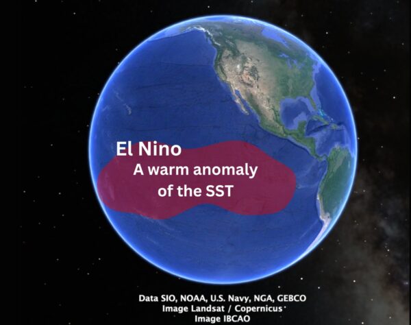
El Nino is a climate pattern characterized by warmer-than-normal sea surface temperatures in the central and eastern Pacific Ocean. This is represented by the red peaks on the previous graph.

El Nino

El Nino Climate Pattern

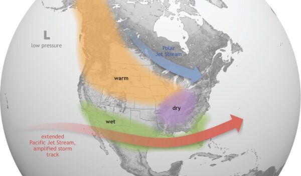
During an El Nino event, the West Coast of North America, including regions like California, Oregon, and Washington, typically experiences significant changes in temperature and precipitation. The warmer ocean temperatures associated with El Niño lead to milder and warmer winter temperatures along the coast. This results in reduced snowfall in the mountains, which can affect water supplies during the summer months.

El Nino

Source: https://oceanservice.noaa.gov/facts/ninonina.html

Strong El Nino Winter of 2023/2024

Ocean Nino Index 2023/2024

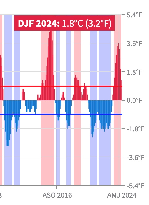
We can see a strong positive anomaly on the graph, represented by the red peak. The Oceanic Niño Index shows a deviation of +1.8°C, which is well past the +0.5°C threshold, indicating a strong El Niño cycle.

El Nino 2023/2024

Source:https://www.cpc.ncep.noaa.gov/data/indices/oni.ascii.txt https://www.ncei.noaa.gov/access/monitoring/enso/sst 


How did the El Nino affect the 2023/2024 winter? 

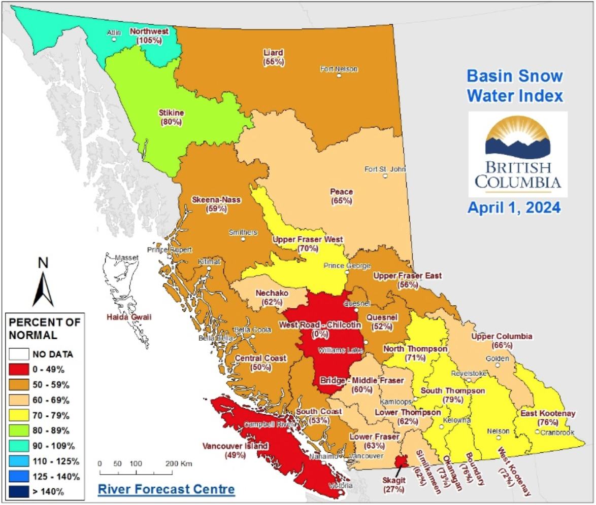
We observed the effects of a strong El Nino. For much of the winter, the snowpack in British Columbia was near a historic minimum.

Here is a visual that summarizes the snow pack accumulation across BC. The overall view is an extremely low snowpack, averaging 63% of normal across BC.

BC Winter 2023/2024 April Snowpack

Source: https://www2.gov.bc.ca/assets/gov/environment/air-land-water/water/river-forecast/2024_apr1.pdf

El Nino Impacts on British Columbia Ski Resorts

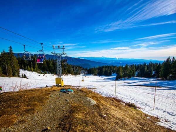
The El Nino cycle was particularly difficult for southern BC ski resorts at lower elevations, which had to close due to a lack of snow. Less accumulation and warmer temperatures often result in less snowpack overall, especially at lower elevations.

BC Ski Resorts El Nino

Source: https://vancouversun.com/news/bc-ski-mountain-calls-off-2023-24-season-over-lack-of-snow 

Avalanches During an El Nino Cycle 

During an El Nino cycle, low snowpack accumulation can mean the snowpack is less favourable for bonding and healing any weak layers caused by rain on snow events. This setup, where a weak layer is created and doesn’t heal, can lead to large avalanches. While this article won’t dive into all the details, it’s important to note that a low snow accumulation year doesn’t mean no avalanches. We saw historic avalanche events in BC this past season due to a rain-on-snow event that created a weak layer which never healed. Essentially, “weird weather leads to weird avalanches.”

Whistler Blackcomb Avalanche

Source: Whistler Blackcomb

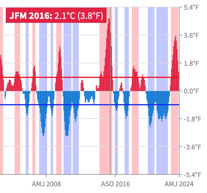
Another Example of a Strong El Nino from 2015/2016 

The ONI deviates again well past + 0.5°C to + 2.1°C indicating a strong deviation and therefor a strong El Nino Cycle.

2015/2016 El Nino

The Snow Survey and Water Supply Bulletin is a great resource in British Columbia gathering data on snow accumulation.

To quote the Snow Survey and Water Supply Bulletin from March 1, 2016 

“Temperatures.. continued to be well above normal… with daily temperatures being 1-3˚C above normal through southern BC, and 3-5˚C above normal through the Kootenays, central, and northern BC. These warm temperatures have persisted throughout the 2015-16 winter (December, January, February), with temperature departures being 1-4˚C above normal across the province over the three month period.”

La Nina Prediction for the 2024/2025 Canada Winter Emerging

NOAA Climate Prediction Centre has issued a La Nina watch. 

The NOAA Climate Prediction Centre Synopsis: ENSO-neutral is expected to continue for the next several months, with La Nina favoured to emerge during August-October (70% chance) and persist into the Northern Hemisphere winter 2024-25 (79% chance during November-January). We are getting set up for a La Nina Canada Winter.

What is La Nina?

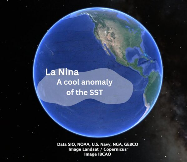
La Nina is a climate pattern characterized by cooler-than-normal sea surface temperatures in the central and eastern Pacific Ocean near the equator.

La Nina

La Nina Climate Pattern

During La Nina, the trade winds strengthen, pushing warm water further west towards Asia. This allows colder water from the deep ocean to upwell, or rise, to the surface along the equatorial Pacific, particularly near the coast of South America.

La Nina

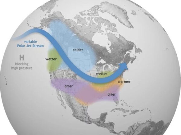
The effects of La Nina on weather patterns are generally the opposite of those caused by El Nino. For the West Coast of North America, La Nina typically brings cooler and wetter conditions. In regions like the Pacific Northwest, this can mean increased snowfall and rain during the winter months.

What to Expect during a La Nina Winter

Looking into the past trends to see if there are any patterns we can extrapolate. Looking back at the ONI graph we can see 1999 was a cool anomaly with respect to the SST. It well below the -0.5°C threshold and is therefore correlated to a strong La Nina cycle.

La Nina 1999

La Nina Canada Winter of 1999

We can reference the Snow Survey and Water Supply Bulletin – 1999 

BC experienced a big winter. Increased precipitation with a colder influence from the polar jet stream. To summarize a section of the report:

“Total precipitation for the winter months continues to be well above normal… Inclement weather has prevented sampling at most or all Vancouver Island snow courses for the March 1 sample period, but other information from ski areas, highways, etc. clearly indicates a very large snowpack… It is interesting to note that a number of the snow pillow stations in the South Coast and Vancouver Island region are not functioning prpoerly. In some cases this is because the snow depths are much greater than ever experienced at these sites and solar panels and sensors have been buried.”

La Nina Winter 1999 Makes the News

A CBC article from 1999 gives us a glimpse of a strong La Nina cycle. Big storms contributing to record snow fall.

La Nina 1999 Winter

Continuing to Monitor the La Nina Trend

At this time we can only see the emergence of the La Nina using the tools provided from the NOAA Climate Prediction Centre. We will continue to monitor the emergence of this coming La Niña cycle and its deviation beyond -0.5°C.  

A La Nina Winter Means Difficult to Manage Inclement Weather

A strong La Nina in British Columbia can lead to significant snowfall, which poses several hazards for highways, mines, pipelines, and other industries operating in remote mountainous areas. Here is a list of potential hazards:

Avalanche Hazard:

  • Increased snowfall can lead to a higher risk of avalanches, impacting highways, mining operations, and other industrial activities.
  • Roads and infrastructure in avalanche-prone areas may face closures or increased hazard from avalanche events.
  • Areas that may have not received as much snow in the past can be at risk to an increasing avalanche hazard.

Road Closures and Traffic Disruptions:

  • Heavy snowfall can cause road closures and traffic disruptions on highways, impacting transportation and logistics for industries.
  • Snow removal and maintenance efforts can strain resource roads and increase operational costs.

Snow Loads:

Access Challenges:

  • Deep snow can make it difficult to access remote worksites, hindering the delivery of supplies, equipment, and personnel.
  • Industries may need to invest in snow clearing equipment to maintain operations.
  • Accessing and repairing pipelines or other infrastructure in remote, snow-covered areas can be challenging with an increasing avalanche hazard.

Impact on Worksites & Projects:

  • Maintaining an accurate weather forecast can insure preparedness for the worksite.
  • Dealing with inclement weather, potential avalanche hazard or snowpack loads in a timely manor will increase safety and operational efficiency.
  • Working with reliable forecasters allows for more predictable operational planning.

Industries operating in British Columbia during a strong La Niña must prepare for these hazards by implementing robust safety measures, emergency response plans, and infrastructure maintenance strategies to mitigate the risks associated with heavy snowfall and adverse winter conditions. 

Reader Interactions

Leave a Reply

Your email address will not be published. Required fields are marked *