Snowpack Supporting Structures and RACS – A New Era of Avalanche Mitigation in Canada

2018 By Brian Gould & Cam Campbell

Abstract

In the avalanche risk management arena, Rogers Pass in Glacier National Park represents the epicenter of avalanche mitigation. A few tragic historical events involving what began as an early 20th century railway corridor inspired scientists and mountain specialists to understand avalanche phenomena and protect those that work and travel in and around it.

When the Trans-Canada highway was built through Rogers Pass in the early 1960s, several structures and systems were put in place to protect the highway and railway through approximately 150 avalanche paths. These include snow sheds, diversion berms, retarding mounds, a forecasting program, and an artillery control program. For over half a century, these structures and systems have successfully managed winter avalanche risk to trains and vehicles that travel this corridor. More recently, increased traffic volumes and decreased tolerance for road and rail delays has resulted in demand for a new era of avalanche risk mitigation that includes over 14 new remote avalanche control systems (RACS), and the largest installation of snowpack supporting structures in the western hemisphere.

This paper explores both the benefits of snowpack supporting structures and RACS, as well as the challenges in installation for two recent large-scale installations in Rogers Pass. It also discusses numerous other installations that have been completed during this new era, along highway corridors and mining roads.

Introduction

The history of snow avalanches impacting transportation corridors in Canada extends back to the early days of the Canadian Pacific Railway (CPR) line through Rogers Pass, between Golden and Revelstoke in British Columbia. Considered a feat of mountain railway engineering in its day, the section through Rogers Pass was exposed to one of the highest concentration of avalanche paths affecting a transportation corridor in the world. After several tragic accidents, and one notable event in March 1910 that resulted in 58 fatalities, protection from snow avalanche risk became a focus in Canada.

After the 1910 accident, measures to protect the railway through Rogers Pass primarily focused on lowering the exposure by the construction of the 8 km long Connaught Tunnel. When the design of the Trans-Canada Highway (TCH) through Rogers Pass began in the late 1950s, there was a developing body of avalanche knowledge, both in Canada and abroad. This resulted in the design of a number of new permanent measures such as snow sheds, berms, and retarding mounds. These measures were supplemented by operational avalanche mitigation which, for the past 56 years, has incorporated avalanche forecasting, temporary highway closures, and 105 mm Howitzers operated by the Canadian Armed Forces to trigger avalanches when the hazard is high. This program is referred to as Operation PALACI and it is jointly coordinated by Parks Canada and the Department of National Defence (DND) to protect the transportation corridors (road and rail) in the park.

In recent years, increasing traffic volumes and decreasing tolerance for travel delays has led Parks Canada to install new avalanche mitigation measures (to complement Operation PALACI) for both the highway and the railway. As a result, in early 2016 Parks Canada commissioned several avalanche mitigation projects that included thirteen Remote Avalanche Control Systems (RACS) and 1937 lineal meters of snowpack supporting structures. The installation of these measures, completed by October 2017, has been the most significant upgrade to the snow avalanche program since the opening of the highway in 1962. In addition to these new installations in Rogers Pass, 23 new RACS installations and 180 m of snowpack supporting structures have been installed in other highway and mining road locations in BC over the past three years.

RACS and snowpack supporting structures are not new technologies (they have been used extensively in Europe as well as other alpine regions for several decades), but the increased pace of installation of these measures suggest there is an emerging new era of avalanche mitigation in Canada.

This paper provides an overview of the recent design and installation of RACS and supporting structures that have been installed in the Rogers Pass corridor. In addition to exploring the benefits to these systems this paper presents a summary of two large-scale installation projects recently completed in the Rogers Pass corridor. Some of the design considerations and challenges are discussed. In addition, some early results are provided.

Rogers Pass Background

Rogers Pass is well known as a heavy snow region, with an average of 14 m of snow falling annually at treeline elevations (J. Goodrich, personal communication, 18 July 2017). The section of highway over Rogers Pass travels through the tracks and runout zones of approximately 134 snow avalanche paths, several of which impact the highway annually, resulting in highway closures and sometimes lengthy traffic delays.

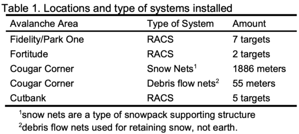
Studies completed prior to 2016 by Parks Canada suggested installations at four key locations would result in improved reliability, and increased efficiency of the operational avalanche control program. The locations, and systems installed, and amounts of each system are summarized in Table 1.

The following two sections review the Cougar Corner and Cutbank installation projects.

Cougar Corner Snow Nets

The Cougar Corner snow nets project was commissioned by Parks Canada to protect a high-risk section of the TCH near the western boundary of Glacier National Park. Considering the character of the terrain and rock in the avalanche paths’ starting zones, the type of snowpack supporting structure system chosen was snow nets. This was due to their ability to absorb rockfall energy. The design-build project involved extremely challenging terrain, both from a design and installation perspective.

Location and Site Conditions

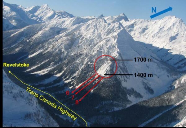
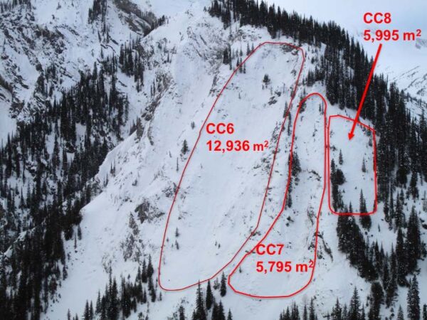
Cougar Corner is located approximately 9 km west of Rogers Pass (Figure 1). The three avalanche paths that were designated for the installation of snow nets are Cougar Corner 6, 7, and 8. The starting zone elevation of the three avalanche paths range between 1400 m and 1700 m. The approximate areal extent of all three starting zones is 24,726 m2, as illustrated in Figure 2.

Rogers Pass Avalanche Mitigation Project

Figure 1. Overview of snow net location

Cougar Corner Rogers Pass

Figure 2. Cougar Corner (CC) paths

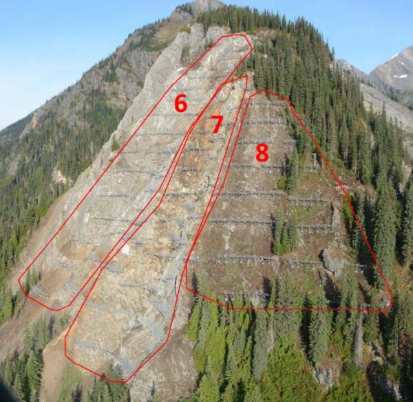
The Cougar Corner site is mainly steep, rugged, and rocky with limited tree cover or vegetation except in Cougar Corner 8 (Figure 3). Complex rock features create several interruptions in the terrain, making it difficult to layout longer rows of barrier structure.

Cougar Corner Rogers Pass Snow Nets

Figure 3. Cougar Corner site with snow nets installed in 2017. Paths outlined in red

Background on Snow Nets

The idea of inhibiting the formation of avalanches in avalanche starting zones goes back more than a century (FAO 1985). Wooden stakes, stone walls and other landscape modifications were built to protect settlements, often after a historic avalanche event had occurred. Since the 1960s there have been significant advancements with snow-supporting structural systems, and in addition to protecting towns and villages, they have been used to protect ski areas, industrial sites, and transportation corridors.

Generally speaking, there are two types of structural systems:

  1. Rigid steel snow-bridges or snow rakes that consist of steel piles and steel profiles bolted together.
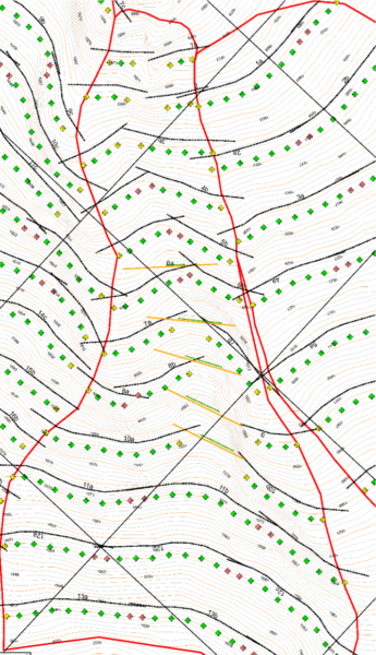
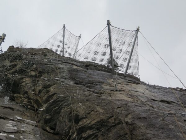
  2. Snow nets with swivel posts, and high-tensile strength mesh (Figure 4).

Avalanche Prevention Snow Nets

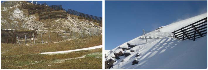
Figure 4. Rigid steel snow–bridges and flexible snow nets side by side

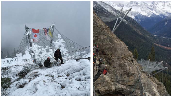
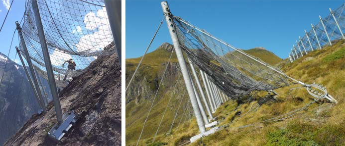
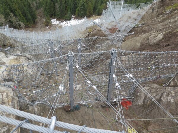
Snow nets have been increasingly applied in areas where rockfall is a problem, or where there is challenging terrain or ground conditions (Figure 5).

Avalanche Prevention Snow Nets

Figure 5. Complex site geometry and conditions above the Trans-Canada Highway near Rogers Pass, BC (right)

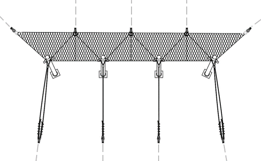
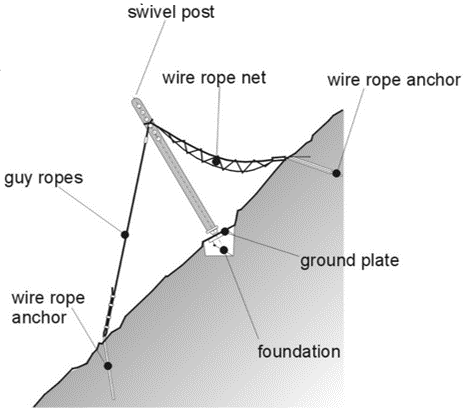
The basic components in a snow net consist of swivel posts, high-tensile steel specialized mesh, anchors and foundation elements (Figure 6).

Snow nets are sized according to thickness of the snowpack, and the design thickness is designated as ‘Dk’. Normally the design thickness for a snow net system is determined by considering the extreme snow depth, or ‘Hk’. The common range of design Dk values for snow nets are from 2.5 to 4.5 m.

There are several advantages to the application of snow nets:

  • Snow net components are light-weight and installation with a helicopter is possible in areas that are otherwise inaccessible.
  • Snow nets are visually less obtrusive compared to rigid structures, which is relevant for tourism and parks.
  • In areas subject to rockfall, the nets can be effectively adapted to the terrain.

The flexible snow-net system adapts to areas in permafrost terrain and creeping unconsolidated rock (e.g. free-standing plates are able to react together with the slope (no stiff, concrete foundation), and seasonal adjustments to the snow net floating base plates (Figure 7) and net structure can be made if there is movement under the net structure itself).

Avalanche Snow Net


Avalanche Prevention Snow Net Design

Figure 6. General components and layout of snow nets

Geobrugg SPIDER avalanche prevention snow net floating base plates.  

Figure 7. Geobrugg SPIDER snow net floating base plates.

Currently, there are two other snow net installations in Canada:

  1. Kicking Horse Canyon – the second installation in Canada. This installation has four rows and protects a segment of the TCH approximately 10 km east of Golden, BC.
  2. 35 Mile Bluffs. This installation was completed in October 2014 and consists of three rows. It protects a short segment of Highway 16 approximately 50 km west of Terrace, BC.

In contrast to these smaller installations, the Cougar Corner project consists of 98 row segments.

Methods

Initial Desktop Design

The “Technical Guidelines for Avalanche Defense Structures in Avalanche Starting Zones” issued in 1990 and revised in 2007 (Margreth 2007) serve as the basis for the development and approval in Switzerland. The Cougar Corner snow nets were designed according to these ‘Swiss Guidelines’, which have become the international standard for snow supporting structures in avalanche starting zones.

These guidelines specify:

  • Fundamental principles for general arrangement and coverage in order to effectively stop large avalanches from releasing, including minimum fence height and maximum separation between adjacent fence segments in a row.
  • Maximum distance between rows of fences down a slope, in order to withstand static snow creep and glide forces.

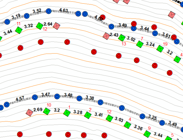
The initial desktop design included terrain analysis using a high resolution (1 m) Digital Elevation Model (DEM) acquired through LiDAR survey of the site when it was snow free. This was used to determine slope shape and incline, identify constraining terrain features, and plan an initial layout (Figure 8).

Gumbel extreme value analysis of historical snow depth data from nearby weather stations was used in conjunction with analysis of snow drifting patterns in historical photographs to determine minimum fence heights. Avalanche starting zone boundaries were delineated from initial outlines provided by Parks Canada and detailed terrain analysis using the 1 m DEM and terrain photographs.

Field Investigations and Layout

Initial field investigations involved analysis of both the large features that were noticed during the desktop phase, and micro-features such as small steps, overhangs, and grooves that generally were not recognizable. These micro-features perhaps posed the most significant challenge on the project, as snow net systems require a certain degree of terrain uniformity and consistent (and competent) rock for the high strength anchors required to sustain the high snow creep and glide forces.

In addition to providing a challenge for the design and layout of the snow nets, the steepness and ruggedness of the terrain presented significant safety risk for personnel on site due to both falling, and rockfall from above. As a result, fall protection (primarily rope access) and rockfall management systems, including extensive scaling, were employed anywhere these hazards exist, which included approximately 75 % of the project site. Although these safety systems resulted in reduced speed and increased time to complete the project, they ensured a safe worksite for the many drillers, installers, and engineers that were on site on a daily basis.

As is typical with snow nets, layout was completed using a combination of cable jigs provided by Geobrugg (the manufacturer), measuring tape, inclinometers, and rangefinders. A Global Positioning System (GPS) with base station was used regularly to position the layout crew in locations designated on the initial desktop design. Dimensions for layout require accuracy for the snow nets to be supported properly in the terrain (Figure 9). Final layout relied extensively on judgement and experience of snow and avalanche engineers, and Geobrugg’s technical representatives.

desktop snow fence layout drawing for Cougar Corner 7 illustrating the avalanche starting zone boundary

Figure 8. Screenshot of the initial desktop snow fence layout drawing for Cougar Corner 7 illustrating the avalanche starting zone boundary (red line), post type and locations (green, yellow and pink squares), uphill toeedge of the Spider nets (black hashed line), and proposed debris flow net locations (orange and green lines)

Quality Control

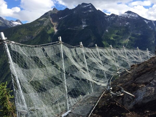
Ongoing quality control occurred during the field layout phase to ensure the layout conformed to the Swiss Guidelines and Geobrugg specifications. A GPS system with GNSS correction was used to survey anchor and post locations that were laid out in the field. These coordinates were then analysed using a Geographical Information System (GIS) to determine spacing between points, distance between rows of fences, separation between adjacent fence segments and inflection angles at post locations (Figure 10).

Cougar Corner 7 Desktop Design

Figure 10. Screenshot of the layout drawing for the lower section of the Cougar Corner 7 starting zone (red outline) showing post (green and pink squares) and anchor (red and blue circles) locations with spacing distances between points (black numbers (m)) and post inflection angles (red numbers (°))

These parameters were then compared to the Swiss Guidelines and Geobrugg specifications and areas that needed adjustment were highlighted. This was an iterative process that provided feedback to the field layout crew on a daily basis.


Challenges

Although several challenges were encountered throughout the design, drilling, and installation of the snow nets, there were a few design situations that required innovative thinking, and concepts that had not been used previously. These challenges mainly revolved around the complexity of the terrain that included several discontinuous features, and an incised gully.

Discontinuous Terrain

Initial field investigations indicated extensive discontinuous terrain, sloping benches, and other terrain discontinuity that would not allow for a continuous snow net system (Figure 11). Although the Spider net system can accommodate continuous fence lengths of up to 60 m, in order to adapt to the discontinuous terrain, as well as wildlife permeability and practical installation purposes, shorter fence segments, typically involving at least two full panels, and 7 to 30 m in length, were used. Essentially, there were several isolated terrain segments that would only accommodate a single central panel of net with 2 triangle end panels, which was referred to as a ‘2-post system’ (Figure 12). Although these 2-post systems had isolated use previous to this project, Cougar Corner incorporated 23 2-post systems which accounted for 24 % of the rows.Avalanche Prevention Snow Net System

Figure 11. Continuous snow net system

Avalanche Prevention Snow Net Post

Figure 12. 2-post system

Incised Gully

The central section of Cougar Corner 7 path is a narrow converging gully that is over 5 m deep and 10 to 15 m wide at its narrowest point. Terrain investigations determined that standard snow nets were not suitable for this location. After discussing with the manufacturer’s technical representatives, it was realized that a debris flow barrier system could effectively be employed. The system is designed for significant loading from debris flow mass, which is much denser and heavier than even the densest snow pack. And the debris flow nets could act as a catchment for any loose snow sloughs that occur between rows of nets. The final installation is illustrated in Figure 13.

Debris Flow Net Barrier

Figure 13. Use of Debris Flow net barrier in CC7 gully


Cutbank Avalanche Area

Location and Site Conditions

The Cutbank avalanche area is located east of Rogers Pass on the eastern boundary of Glacier National Park approximately 40 km northwest of Golden, BC. Although the avalanche paths only affect the railway alignment, they were previously controlled with artillery that was fired from the highway, which required highway closures. Furthermore, mobilization time was higher due to location being far away from the primary artillery program. Therefore, the installation of RACS at this site is expected to reduce highway closure times and increase efficiency of avalanche control.

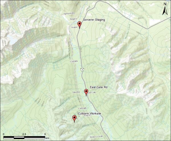
The RACS installations are located in a remote location near treeline, which required helicopter access. Every day, work crews, materials and equipment were flown in from either one or both staging areas as shown in Figure 14.

Rogers Pass on the eastern boundary of Glacier National Park

Figure 14. Overview map of the Cutbank project area showing the worksite as well as the two helicopter staging areas: Sorcerer and East Gate Rd

Background on RACS

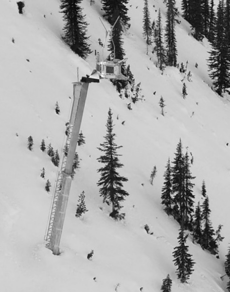
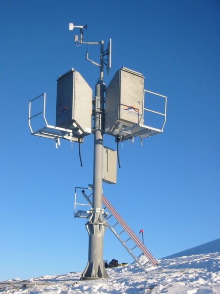
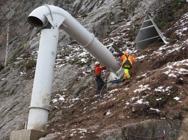
Remote Avalanche Control Systems (RACS) refers to any avalanche explosive control system that is installed in and around starting zones and uses telemetry and electronics to relay and transmit a coded triggering sequence from a computer (office or mobile device) to a fixed installation on the mountain. RACS may incorporate cast explosives (tethered or mortar based) (Figures 15 & 16) or gas mixture that is detonated by a timed ignition sequence (Figure 17). The Cutbank avalanche paths incorporates the Wyssen® Tower system (Figure 15), while the Fortitude and Fidelity/Park One avalanche paths employ the Avalanche Guard® system (Figure 16). Parks Canada also has several Gazex® installations along the TCH as well as the Sunshine ski area road, since 1996.

Wyssen Tower Remote Avalanche Control System

Figure 15. Wyssen Tower explosives-based RACS. This Wyssen Tower system was installed at Cutbank during summer 2017

Avalanche Guard Remote Avalanche Control System

Figure 16. Avalanche Guard RACS system. As of 2016, there are six of these systems installed at Fortitude and Fidelity/Park One avalanche paths near Rogers Pass (photo courtesy of BC Ministry of Transportation and Infrastructure)

Gazex Remote Avalanche Control System

Figure 17. Gazex ® gas-based RACS. As of 2017, there are six Gazex exploder installations in paths affecting the TCH, approximately 10 km west of Lake Louise

The Wyssen Towers used for the Cutbank project is a selfcontained unit consisting of a portable explosives magazine deployment box that is seasonally installed on top of a remotely installed inclined mast (Figure 15). Inside the portable deployment box are 12 tethered charges preloaded into a mechanically rotating tray (dispenser). The initiation sequence involves a release of a suspended charge on a tether up to 14 m in length above the start zone.

The operational unit is removed and replaced remotely by helicopter long-line transport system, which allows for maintenance and reloading of explosives in a comfortable location in the valley. The magazine has a capacity of 12 charges of up to 5 kg each.

The main advantages of the Wyssen Tower include the portability of the deployment box (for worker safety, ease of reloading and maintenance, and summer storage), and the significant effective range of the air blast from the suspended charge (up to a 130 m fracture radius).

Design Methods

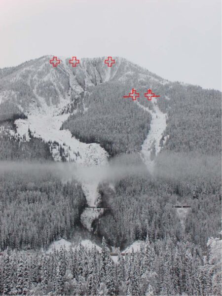
The initial requirement for the project was to ensure that all artillery targets could be impacted by the new RACS. This was accomplished through detailed field studies as well as a GIS-based viewshed analysis. The final result was five Wyssen Towers as shown in Figure 17.

Remote Avalanche Control Start Zone

Figure 17. Photo of the Cutbank avalanche paths from the Trans-Canada Highway. Approximate Wyssen Tower locations are shown (red crosses). The two railway alignments can be seen lower in the avalanche path

Challenges

Fire Hazard and Smoke

The foundation construction and tower installation took place over a period of three months over the summer 2017. This was a period of intense forest fire activity in southern BC, including two large fires in proximity to the project site. As such, there were challenges for flying work crews and especially long-lining materials and equipment with the reduced visibility caused by the smoke.

Furthermore, due to the fire hazard, fuel could not be left unattended at the worksite. This meant that all fuel had to be flown off site at the end of the work day and back on site every morning, which significantly increased the amount of helicopter long-lining required.

Subsurface Conditions

The subsurface conditions encountered after drilling commenced were significantly different than expected. Poor quality rock was encountered at most foundation locations, which required anchoring methods to be adjusted. Solutions included significantly deeper anchors and hole casings, which required different drilling equipment and considerably more grout than originally planned.

Conclusion

Both the Cougar Corner snow net and recent RACS projects at Rogers Pass represent a milestone for avalanche mitigation in Canada and the world. Not only is the Cougar Corner snow net project installation significant in size, it also incorporates innovative design concepts that would not have been possible without the collaborative effort that ensued on the project. The Cutbank and other RACS projects represent a significant upgrade to existing control methods that will assist in reducing total highway closure time, and improve highway safety and reliability.

The snow nets and RACS discussed in this paper have all been tested during the above average winter of 2017/2018, and the initial feedback is promising. The Cutbank snow nets and associated debris flow fences have supported substantial snow loads, and the Cutbank RACS has triggered medium and large size avalanches to reduce risk to the railway.

Acknowledgements

The authors would like to acknowledge the following primary organizations and companies that were involved in the recent avalanche mitigation projects in Rogers Pass:

  • Parks Canada Agency – the owner.
  • McElhanney Consulting Services Ltd. – the owner’s engineer.
  • BAT Construction Ltd. – the prime contractor for Cougar Corner.
  • Wyssen Avalanche Control Inc. – the prime contractor as well as manufacturer and supplier of avalanche control towers.
  • Geobrugg AG – the snow net manufacturer.
  • Axis Mountain Technical – the construction lead for Cutbank.

We would also like to thank, Marnie DiGiando, Ryan Calder, and Jeff Goodrich from Parks Canada for reviewing this paper.

References

Canadian Avalanche Association. (2016). Technical Aspects of Snow Avalanche Risk Management – Resources and Guidelines for Avalanche Practitioners in Canada (C. Campbell, S. Conger, B. Gould, P. Haegeli, B. Jamieson, & G. Statham Eds.). Revelstoke, BC, Canada: Canadian Avalanche Association

Food and Agriculture Organization of the United Nations (FAO). 1985. Avalanche Control, FAO, Rome, Italy.

Gould, B., Campbell, C, & Buechi, A. 2017. Breaking New Ground – Using Fixed Snow Nets to Mitigate Avalanche Risk to the Trans-Canada Highway, Proceedings of Geo-Ottawa 2017 – the 70th Canadian Geotechnical Conference, October 1-4, 2017.

Jamieson, B. (ed.), 2017. Planning Methods for Assessing and Mitigating Snow Avalanche Risk, (contributions by Jamieson, B., Jones, A., Argue, C., Buhler, R., Campbell, C., Conlan, M., Gauthier, D., Gould, B., Johnson, G., Johnston, K., Jonsson, A., Sinickas, A., Statham, G., Stethem, C., Thumlert, S., Wilbur, C.). Canadian Avalanche Association, Revelstoke, BC, Canada.

Margreth, S. 2007. Defense Structures in Avalanche Starting Zones – Technical Guideline as an aid to Enforcement. Federal Office of the Environment, Bern, Switzerland.