Snow Avalanches, in Resilient Pathways Report: Co-creating new Knowledge for Understanding Risk and Resilience in BC

August 15, 2024 By BY: Cam Campbell, Alpine Solutions Avalanche Services Pascal Haegeli, Simon Fraser University CONTRIBUTORS: Bruce Jamieson, University of Calgary Joe Obad, Canadian Avalanche Association Karl Klassen, Avalanche Canada Robb Andersen, BC Ministry of Transportation and Infrastructure Avalanche Program Grant Statham, Parks Canada EDITORS: Sahar Safaie, Sage On Earth Consulting Shana Johnstone, Uncover Editorial + Design

What is Resilience Pathways Report?

Resilience Pathways is a knowledge-sharing initiative that recognizes that everyone—all of society—has a role in designing our resilience to disaster and climate risk.

This article is part of the Resilience Pathways Report. The report has the following objectives: a) to share knowledge about existing practices and recent advances in understanding and managing disaster and climate risk in BC, including some information on relevant federal programs, and b) to provide insights on gaps and recommendations that will help build pathways to resilience in BC. This article belongs to Chapter 1 Understanding and Managing Climate and Disaster Risk: Hazard Threat. To read all articles in the report, see DRRPathways.ca. The Resilience Pathways Report is a project of Natural Resources Canada.

Video Summary Presented by Cam Campbell

Full Report Video Link

About Snow Avalanches

Description

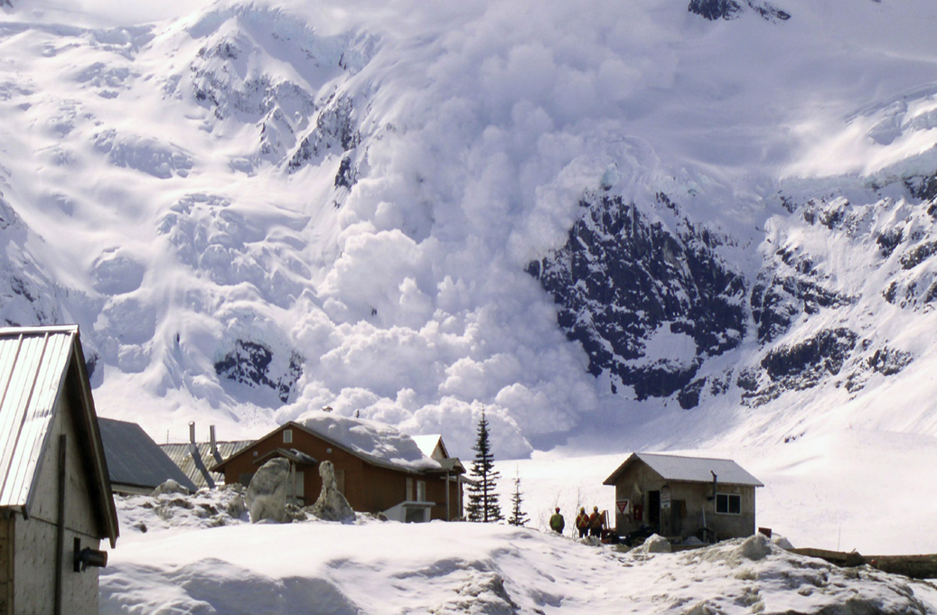
Snow avalanches are rapid, gravity-driven mass movements of snow that start on slopes of sufficient steepness (Figure 1). Large avalanches can encompass more than 10,000 tonnes of snow and run for kilometres with speeds up to 200 km/h and impact pressures on the order of 1,000 kPa.

Avalanche release is determined by complex interactions between terrain, the sequence of weather events that produced the local snowpack, current weather conditions, and the triggering mechanism. The most fundamental and constant indicators for assessing whether a slope with sufficient snow cover has the potential to release avalanches are slope incline and forest density. Avalanches typically require relatively open slopes steeper than 25 degrees to start and accelerate, but the most common slope angles are between 30 degrees and 45 degrees. Once released, large avalanches travel downslope along the avalanche track until they reach the runout zone where the terrain is consistently less than 15 degrees steep. It is in this area where the avalanche debris decelerates and is deposited. However, the exact runout distance of an avalanche depends on the total amount of snow released and the specific terrain characteristics of the entire path. While avalanches typically do not release on densely forested slopes, they can run into forested terrain and destroy mature timber. This means that most mountainous terrain in BC with sufficient snowfall is either capable of producing avalanches or potentially threatened by avalanches from above. In addition to natural avalanche terrain, human-made structures such as roofs, dam faces, and steep cutbanks are also able to produce avalanches.

People and assets located in avalanche paths can be damaged or destroyed by avalanches. Examples of threatened assets include occupied structures, transportation infrastructure including vehicles and occupants, critical energy or communication infrastructure, and natural resources and associated development infrastructure. In addition to these direct impacts, avalanches can also have secondary impacts. Examples include transportation or production delays as well as financial, legal, and reputational impacts. Short- and long-term psychological impacts from avalanche accidents have been documented but are not routinely monitored.


An explosive controlled avalanche at the Galore Creek Project located in northwestern British Columbia, CanadaFigure 1: An explosive controlled avalanche at the Galore Creek Project located in northwestern British Columbia, Canada (Photo: Wayne Ball).

Avalanche Threat and Past Events

There has been a distinct evolution in the nature of avalanche accidents in BC. Prior to about 1970, avalanche accidents primarily involved transportation infrastructure, resource industries, or buildings. Examples of some of the most noteworthy accidents during that period include the railway accident on Rogers Pass on March 4, 1910 (58 railway workers killed), the Granduc Mine accident on February 18, 1965 (26 mine workers killed), and the North Route Café accident on Highway 16 west of Terrace on January 22, 1974 (seven stranded motorists killed). All of these accidents occurred during major winter storms that resulted in widespread avalanche activity. They caused substantial property damage and killed individuals who involuntarily and possibly unknowingly exposed themselves to the hazard.

Since 1970, the majority of avalanche fatalities have involved winter backcountry recreationists who voluntarily exposed themselves and accidentally triggered avalanches while travelling in mountainous terrain. The shift from industrial to recreational accidents was due to a combination of improved avalanche risk management in non-recreational settings (i.e., highways, railways, mines, developments, etc.) as well as the growing popularity of winter backcountry recreation. Most of these post-1970 accidents resulted in single or double fatalities, but larger, multi-casualty accidents have also occurred (e.g., Canadian Mountain Holidays Bay Street with nine fatalities on March 13, 1991; Connaught Creek with seven fatalities on February 1, 2003; Harvey Pass with eight fatalities on December 28, 2008). ince 1981, 95% of the 458 avalanche fatalities in Canada involved backcountry recreationists, and 72% of these individuals perished in BC. At the time of this writing, an average of ten individuals are killed in avalanches in Canada every year and eight of them typically occur in BC.

Drivers of Risk

The main anthropogenic driver of recent changes in avalanche risk is increased exposure to avalanche hazard. While there are no systematic observations of more people in uncontrolled (backcountry) terrain, indirect indicators (e.g., sales of backcountry recreation equipment) show that the popularity of winter backcountry recreation has increased tremendously over the last decades, as have traffic volumes on mountain roads and highways. Natural resource extraction and associated infrastructure developments are also pushing further into mountainous terrain, and wildfires and construction activities such as deforestation, slope or rock cuts, or the construction of dam faces can create new avalanche terrain. At the same time, avalanche risk has been mitigated through improved avalanche planning, expanded public safety programs and resources, advances in avalanche safety and rescue equipment, tightened worker safety regulations and land-use policies, continued development and enrolment in training programs for recreationists and avalanche professionals, and advancements in understanding and forecasting of avalanche hazard.

Understanding Risk

What Sources Help Us Understand Hazard and Risk

Avalanche risk is the probability or chance of harm resulting from interactions between avalanche hazard and specific assets, and it is determined by the exposure of those assets and their vulnerability to the hazard. To describe how avalanche hazard and risk are assessed, it is best to distinguish between long-term avalanche planning and short-term operational avalanche forecasting as they use distinct techniques and information sources. However, in both contexts, the risk assessment process consists of identification, analysis, and evaluation.

Avalanche Planning

Avalanche planning aims to assess the long-term potential for avalanches to impact a specific asset at a defined location. After confirming that the location of interest is threatened by avalanches based on a basic terrain and snow supply analysis, the risk analysis process starts with estimating the local return periods for avalanches and their destructive potential. Methods for determining long-term avalanche hazard include analysis of historic avalanche records and identification of vegetation damage through analysis of air photos and satellite imagery as well as field surveys including tree-ring analysis. This direct evidence is complemented with the output from numerical avalanche models, which estimate the maximum runout distance and simulate the flow characteristics of potential avalanches. Estimates of frequency and magnitude are then combined with estimates of the exposure and vulnerability of the assets to determine the risk level.

Operational Avalanche Forecasting

Operational avalanche forecasting is used in situations where permanent protection from avalanches is either impractical (e.g., for mobile assets such as backcountry users) or economically not meaningful (e.g., too expensive for the given exposure, such as on roads with low traffic volume), or it is used to manage residual risk after suitable long-term mitigation has been applied.

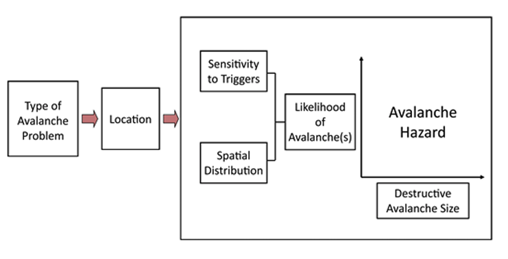
In these cases, the focus is on assessing the current (e.g., daily) level of avalanche hazard to direct and implement short-term mitigation measures, such as temporary closures or the use of explosives to proactively trigger avalanches before or when they become threatening. Avalanche forecasters assess the nature and severity of the current hazard conditions based on a qualitative synthesis of available weather, snowpack and avalanche observations, and their knowledge of the local terrain. Forecasters address the natural uncertainty associated with observations with targeted sampling and by assimilating evidence incrementally over time. While deductive methods are used to analyze some data, the assessment process is dominated by inductive and adductive logic and uses experience based heuristics. The Conceptual Model of Avalanche Hazard (Figure 2) describes the essence of the qualitative forecasting process as a systematic workflow that answers four sequential questions: 1) What type of avalanche problem exists? 2) Where are these problems located in the terrain? 3) How likely is it that avalanches will occur? and 4) How big will these avalanches be?

Conceptual Model of Avalanche Hazard

Figure 2: Conceptual Model of Avalanche Hazard used for day-to-day operational avalanche forecasting. Avalanche hazard is often represented as a range of values for both likelihood of avalanche and destructive size, representing variability and uncertainty.

Operational avalanche forecasting programs are common in BC and exist in many different contexts. Examples include mountain highway passes and railway lines, mine and construction sites with associated access roads, winter backcountry recreation operations, and ski areas. In most circumstances, the avalanche risk is assessed and managed in situ by a team of avalanche safety professionals who collect detailed weather, snowpack and avalanche observations to assess the local conditions throughout the winter season. To ensure a high degree of awareness about developing conditions, avalanche safety operations in BC share their observations and assessments via InfoEx, a private and confidential information exchange managed by the Canadian Avalanche Association. In addition, avalanche forecasting programs utilize remote automated weather stations and mountain weather forecasts. Numerical snowpack models that simulate the evolution of the seasonal snow cover can be used as an additional information source in areas that are otherwise data sparse.

Public Avalanche Warning Services

Public avalanche warning services are special types of avalanche forecasting programs that inform the general public about current avalanche conditions and help self-directed winter recreationists make informed decisions about when and where to travel in the backcountry. Agencies involved in public avalanche safety in BC include Avalanche Canada, a non-government, not-for-profit organization dedicated to public avalanche safety, and Parks Canada. Together, these agencies publish daily avalanche hazard forecast bulletins for approximately twenty regions that range in size from roughly 1,000 km square to more than 50,000 km square. While smaller forecast regions are fieldbased, where forecasters go into the field to collect their own observations for writing the forecast (e.g., Glacier National Park), the programs for larger forecast regions are typically officebased, where forecasters primarily rely on observations collected and shared by others (e.g., InfoEx, Mountain Information Network, dedicated field teams) and the conditions are assessed remotely. This is currently the approach for most Avalanche Canada forecast regions.

While Avalanche Canada maintains an avalanche incident database that is searchable by the public, it does not have an official mandate to investigate avalanche accidents. However, Avalanche Canada and the Canadian Avalanche Association assist the BC Coroners Service to ensure it has the necessary avalanche expertise when investigating fatal avalanche accidents. Since there is no legal requirement to report or investigate non-fatal avalanche accidents, the available avalanche accident information primarily focuses on fatalities for which reliable records exist. While these reports provide insightful case studies, the lack of dependable exposure information (i.e., the number of recreationists who use the backcountry every winter) prevents the calculation of meaningful accident rates. An exception is the mechanized skiing industry, where the number of skier days has been recorded systematically since the 1970s. Information on other impacts of avalanches (e.g., property damage, economic impact of road closures) is currently not collected systematically.

Current Practice in Hazard and Risk Assessment

Since the early 1980s, the Canadian Avalanche Association has published guidelines and standards that have shaped how avalanche hazard and risk is assessed and mitigated in BC. The most recent editions of these documents include Technical Aspects of Snow Avalanche Risk Management – Resources and Guidelines for Avalanche Practitioners in Canada (TASARM) and Observation Guidelines and Recording Standards for Weather, Snowpack and Avalanches (OGRS). The TASARM document provides a comprehensive overview of best practices in the technical aspects of snow avalanche hazard and risk assessment and mitigation and suggests guidelines for acceptable risk and typical assessment processes and mitigation options. The risk management concepts presented in TASARM are firmly grounded in the International Organization for Standardization risk management standard known as ISO 31000 Risk Management — Principles and Guidelines. The OGRS document describes the terminology, techniques, and data codes for making and recording avalanche, snowpack, and mountain weather observations. This long history of standard documents has resulted in a high degree of harmonization in the data collection procedures and hazard and risk assessment practices and has been crucial for the industry-wide exchange of avalanche safety information in Canada.

Avalanche on Road

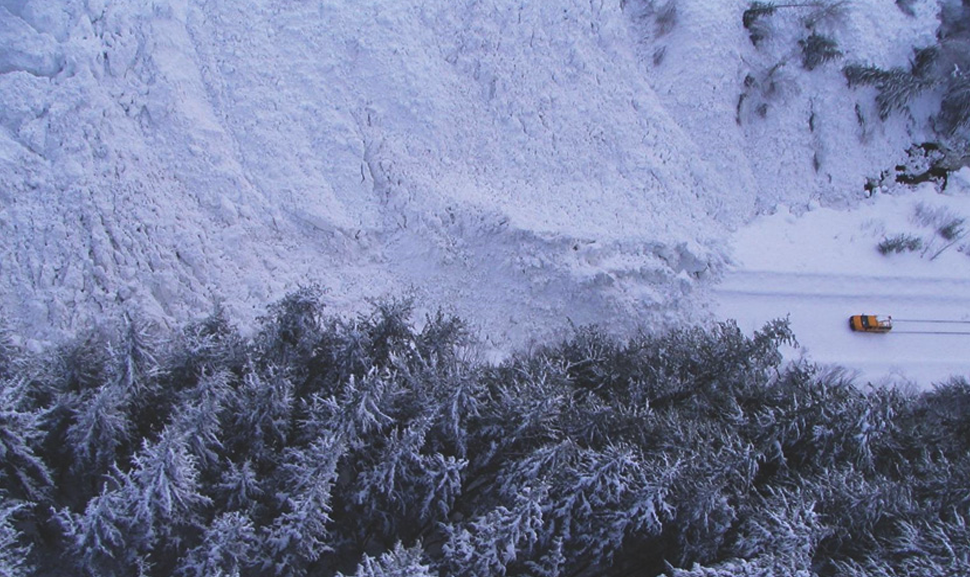
Figure 3: Canyon and truck (Photo: Mark Austin).

Reducing Risk

Practice and Capabilities

Avalanche risk mitigation (or risk acceptance) decisions are always based on a risk evaluation where the assessed risk level is compared against risk acceptance levels. These evaluations and the resulting avalanche risk reduction practice, policy, and capabilities depend heavily on context. Most approaches focus on managing exposure to the existing hazard, while approaches that modify the hazard (e.g., avalanche control) or decrease the vulnerability of assets (e.g., avalanche rescue training and equipment) are typically of secondary importance.

Involuntary Risk Exposure

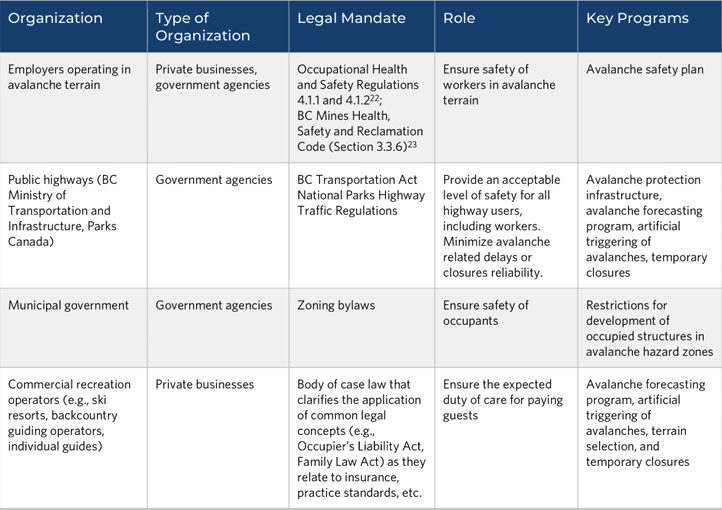
Actions taken to reduce risk to facilities, infrastructure, and individuals who involuntary expose themselves to avalanche risk are typically a combination of long-term planning and short-term operational avalanche risk management. While regulatory standards for worker and public safety are well defined (see Table 1), risk acceptance benchmarks for non-human assets are context dependent and typically defined by the risk owner based on a mitigation cost-benefit analysis that aims to reduce the residual risk to “as low as reasonably practical” (ALARP). Location planning (i.e., considering avalanche hazard when evaluating location options) is often the first step taken to reduce risk to fixed facilities or infrastructure. Avalanche hazard zoning, with associated bylaws and access policies, is typically used to restrict development of occupied structures in avalanche areas. If relocation is not an option, then engineered avalanche protection is considered. Currently, avalanche hazard zoning in BC is conducted on a case-by-case basis for new developments with updated hazard zone mapping, using modern methods for some communities with existing zoning (e.g., Stewart and Fernie).

If these protection measures cannot reduce the risk to an acceptable level or are economically not feasible, seasonal closures are considered except in situations where long closures are unacceptable (e.g., highways, ski areas, active work sites). In these circumstances, avalanche professionals will use short-term risk reduction actions (e.g., temporarily restricting access to exposed areas during periods of elevated hazard) based on operational avalanche forecasting. In industrial situations where the threat from avalanches is infrequent and relatively low, risk reduction actions have also been based on regional hazard assessments published in public avalanche bulletins. Risk management at work sites typically includes avalanche safety training and rescue equipment for workers with ongoing avalanche hazard assessment by an avalanche professional. If deemed cost-effective, artificial avalanche triggering (e.g., explosive avalanche control) can be used to proactively reduce the hazard and minimize closure times.

Voluntary Risk Exposure

While the responsibility for the risk assessment and mitigation actions in the above contexts resides with avalanche professionals and ultimately the risk owner, avalanche risk management practices for self-directed backcountry recreation depends on the initiative and self-reliance of the involved public. Key components of backcountry avalanche safety include recreational avalanche safety training, detailed trip planning, route finding, group management, and avalanche rescue equipment (e.g., avalanche transceivers, probes, shovels, air bags) as a last resort. Most actions taken to reduce risk are short-term measures that are applied on a day-to-day basis. This includes using up-to-date avalanche condition information when planning trips, continuously monitoring conditions when in the field, choosing terrain that matches risk tolerances, and following safe travel practices (e.g., spreading out and only exposing one person at a time).

Infrastructure, Technology, and Tools

Existing infrastructure, technology and tools that support the management of avalanche risk in all contexts include information exchange platforms such as Canadian Avalanche Association’s InfoEx (avalanche professionals only), Association of Canadian Mountain Guides’ Mountain Conditions Report (information from avalanche professionals that is publicly available), and Avalanche Canada’s Mountain Information Network (public information) where avalanche professionals and recreationists can share information about current avalanche conditions. In addition, several networks of remote automated weather stations provide real-time weather data that are used extensively by professional avalanche forecasters and self-directed recreationists for assessing current avalanche conditions, and historical weather data from these networks are used by avalanche consultants and researchers for climate characterizations.

Evolutions of Practice

The evolution of avalanche safety practices in BC and Canada has largely been driven by practice reviews and recommendations following fatal accidents. The standard for avalanche safety on highways, for example, was shaped considerably by the North Route Café accident on Highway 16 in 1974, which resulted in the formation of the BC Ministry of Transportation and Infrastructure’s Avalanche Program and associated regulations for occupied structures, as well as the Five Mountain Parks Highway Avalanche Study commissioned by Parks Canada in 1993. The recommendations in a BC Coroners Service report that examined a fatal heli-skiing avalanche accident that killed seven skiers in 1979 were the initial impetus for creation of InfoEx.

In terms of public avalanche safety, the Parks Canada Backcountry Avalanche Risk Review that examined the 2003 Connaught Creek avalanche accident where seven high school students were killed, led to the establishment of a national centre for public avalanche safety, now known as Avalanche Canada, as well as the development of new public backcountry avalanche safety tools such as the Avalanche Terrain Exposure Scale and the Avaluator. Similarly, BC Coroner Service responded to the record number of mountain snowmobiling fatalities in 2009 with a rare death review panel, whose recommendations provided a roadmap for enhancing public avalanche safety initiatives in BC and mobilized increased funding from local, provincial, and federal sources.


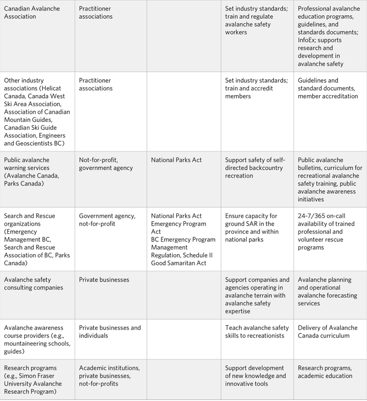
Table 1 lists general or specific organizations involved in avalanche risk management with any associated legal mandates and current roles and key programs.

Climate Impacts

Due to the tight link between weather and avalanche hazard, it is reasonable to expect that climate change will have a substantial impact on the nature of avalanche activity in BC. Direct research on the effect of climate change on avalanche hazard in BC is limited, snow science Table 1: Organizations involved in avalanche risk management principles and research from other mountain regions offer valuable insight. At lower elevations close to the freezing level, we expect that rising temperatures will result in a substantially reduced and eventually disappearing snowpack. While this will cause avalanche initiation to ultimately cease at these elevations in the long term, we might see a higher prevalence of wet snow avalanches during the transition period and the occasional winters with sufficient snow. Furthermore, avalanches can start above and threaten areas below with little or no snow on the ground (i.e., there can be an avalanche hazard in areas with no snow). At higher elevations where snow remains abundant, changes in avalanche hazard will primarily be determined by how climate change will affect the intensity and sequence of winter weather events that determine the nature and severity of avalanche conditions. Since long-term avalanche risk management planning relies heavily on historical weather, snowpack, and avalanche occurrence data, climate change adds considerable uncertainty to predicting future avalanche hazard characteristics, such as long-term frequency and magnitude relationships and extreme runout extent. To account for this increased uncertainty, avalanche professionals typically use a factor of safety when planning avalanche risk mitigation measures. Since day-today operational avalanche forecasting decisions are based on the weather and not long-term climate trends, climate change is not expected to overly affect existing risk management approaches. However, higher year to-year variability in conditions will result in more unusual winters that make judgements informed by previous experiences less reliable. Furthermore, more common extreme weather events may result in more frequent extreme avalanche cycles that have the potential to overwhelm the existing mitigation practices and emergency response plans.

Gaps

While we judge the level of understanding of avalanche risk in BC to be relatively high, there are several gaps in the available information and knowledge that prevent the risk from avalanches in BC from being managed more effectively.

Since avalanche hazard is spatially and temporally highly variable, one of the most significant limiting factors for accurate and timely avalanche forecasts is the general sparsity of high-quality weather, snowpack, and avalanche observations across much of BC’s mountain ranges. While the use of numerical snowpack models can partially address the lack of direct observations, these simulations rely on accurate weather forecasts. Possible approaches for addressing this issue include developing better precipitation forecasts, expanding the existing network of high-elevation weather observation sites, and providing ongoing support for research on how to best use snowpack modelling and advance satellite-based remote detection of avalanche deposits.

Another significant limiting factor for using existing avalanche planning practices to their full potential is the lack of high-resolution, publicly available terrain and forest cover datasets. Existing research highlights that digital elevation models and landcover information with a spatial resolution of at least 10 m is necessary to reliably identify potential release zones using GIS algorithms and accurately model the runout of extreme avalanches. In addition, the lack of mountain range–specific calibrations for numerical avalanche dynamic models further limits their effective use in BC. Addressing this data gap would allow for more detailed and widespread avalanche terrain mapping across all types of avalanche risk management contexts. This includes the computation of impact-based hazard maps for land-use planning and the use of automated algorithms to generate avalanche terrain exposure maps for recreationists.

With respect to public avalanche forecasting, the large size of many forecast areas naturally limits the precision and amount of detail that can be included in avalanche bulletins. Hence, having the resources to decrease the size of forecast regions or temporarily adjust their boundaries would allow bulletins to be more specific. However, avalanche bulletins describing the existing hazard conditions need to be complemented with terrain guidance products to provide recreationists with tangible advice on what type of terrain choices are appropriate under different types of hazard conditions. To design these types of products in an informed way, a better understanding of the desires, needs, existing capabilities, and expectations of the increasingly diverse backcountry community is required. While there have been several exploratory research projects on this topic more work is needed to better understand the users and design a more inclusive and integrated avalanche awareness education system. And while the lack of accurate information on trends in backcountry recreationists prevent the calculation of accident rates, a meaningful collection of backcountry use numbers across BC is challenging and likely extremely costly.

Though the lack of well-grounded understanding of the effect of climate change on future avalanche conditions adds substantial uncertainty to existing practices and thresholds, we perceive a more significant climate change vulnerability: the lack of coordinated disaster planning for large-scale avalanche cycles (i.e., intense avalanche activity across substantial parts of BC for multiple days in a row) coming from the more frequent occurrence of extreme weather. Large-scale avalanche cycles would result in widespread avalanche activity running beyond historic paths, multi-day closures of every transportation corridor in the province, disruption of critical power transmission lines, and communities isolated for extended periods of time. Targeted interagency disaster planning is necessary for responding to such a disaster in a meaningful way.


Opportunity

Recommendations

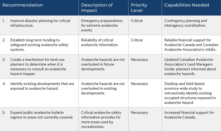
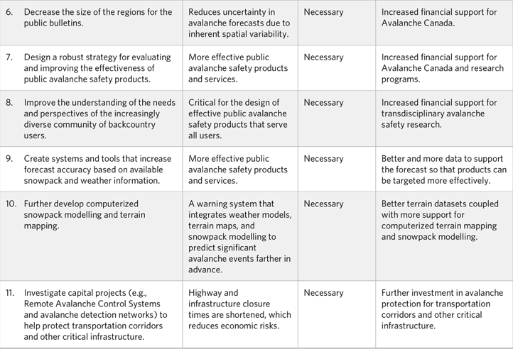
Avalanche safety in BC has largely been a success story, yet there are many opportunities to improve the system. While the gaps described in the previous section primarily relate to information and knowledge challenges, the recommendations listed in Table 2 target higher-level systems improvements.

The Challenge

While the avalanche risk management safety systems in BC are well regarded around the world, it is important to point out that they suffer from a fundamental economic vulnerability that many decision makers might not be aware of. Avalanche Canada’s public avalanche bulletins and, by extension, InfoEx have been critical components of the WorkSafe BC–legislated avalanche safety plans of many businesses and government agencies. The provision of this critical information by not-for-profits differs considerably from approaches taken for managing other natural hazards, such as where government agencies play a more central role in the collection and interpretation of the hazard information and the dissemination of warning messages. Relying exclusively on not-for-profits and private businesses for the provision of these essential services for local economies comes with substantial societal risks.

To enhance BC’s resilience to natural hazards, it is important that avalanche risk management strategies are considered at the same level as other natural hazards and included in the planning process for the economic development of the province. The first step to addressing this challenge is to raise awareness about the seriousness of avalanche hazard in BC and the vulnerability of the current safety systems. Once this awareness is established, key stakeholders should collaboratively investigate feasible long-term models to safeguard existing avalanche safety systems. Integrating avalanche risk management into a broader geohazard strategy might offer a promising pathway for improving the sustainability of the existing safety system and strengthening BC’s avalanche risk resilience.


Resources

1. Technical guidelines for planning and operational avalanche risk assessment and mitigation:

Canadian Avalanche Association. Technical Aspects of Snow Avalanche Risk Management – Resources and Guidelines for Avalanche Practitioners in Canada. Revelstoke, Canada: Canadian Avalanche Association, 2016. https://www.avalancheassociation.ca/resource/resmgr/standards_docs/ tasarm_english.pdf

2. A book outlining field and desktop methods for planning-level avalanche risk assessment and mapping:

Jamieson, Bruce. Planning Methods for Assessing and Mitigating Snow Avalanche Risk. Revelstoke, Canada: Canadian Avalanche Association, 2018.

3. Technical background material on avalanche formation and release, including forecasting and mitigation:

McClung, David, and Peter Schaerer. The Avalanche Handbook. 3 ed. Seattle, USA: The Mountaineers, 2006.

4. Summary and analysis of fatal avalanche accidents in Canada:

Stethem, Chris, and Peter Schaerer. Avalanche Accidents in Canada I – a Selection of Case Histories of Accidents, 1955 to 1976. NRCC Publication 18525. Ottawa, Canada: National Research Council of Canada, 1979.

Stethem, Chris, and Peter Schaerer. Avalanche Accidents in Canada II: A Selection of Case Histories of Accidents, 1943 to 1978. NRCC Publication 18525. National Research Council of Canada, 1980.

Schaerer, Peter. Avalanche Accidents in Canada III. A Selection of Case Histories 1978-1984. NRCC Publication 27950. National Research Council of Canada, 1987.

Jamieson, Bruce, and Torsten Geldsetzer. Avalanche Accidents in Canada, Volume 4, 1984-1996. Revelstoke, BC, Canada: Canadian Avalanche Association, 1996.

Jamieson, Bruce, Pascal Haegeli, and David Gauthier. Avalanche Accidents in Canada, Volume 5, 1996-2007. Vol. 5, Revelstoke, Canada: Canadian Avalanche Association, 2010.

5. Freely available online avalanche tutorial for backcountry recreationists: Avalanche Canada. “Avy Savvy – Avalanche Canada’s Online Avalanche Tutorial.” https://avysavvy.avalanche.ca/en-ca.

Citation

Recommended citation

Safaie, S., Johnstone, S., and Hastings, N.L., (ed.), 2022. Resilient pathways report: co-creating new knowledge for understanding risk and resilience in British Columbia; Geological Survey of Canada, Open File 8910, 327 p. https://doi.org/10.4095/330521

Information contained in this publication or product may be reproduced, in part or in whole, and by any means, for personal or public non-commercial purposes, without charge or further permission, unless otherwise specified. The reproduction is a copy of an official work that is published by Natural Resources Canada (NRCan) and that the reproduction has not been produced in affiliation with, or with the endorsement of, NRCan.

Commercial reproduction and distribution is prohibited except with written permission from NRCan. For more information, contact NRCan at copyright-droitdauteur@nrcan-rncan.gc.ca.

Permanent link: https://doi.org/10.4095/330521

This publication is available for free download through GEOSCAN (https://geoscan.nrcan.gc.ca/).